New
temperatura
New
Cluster GFS ENS
New
opad
New
Cloud Forecast P
region - COAMPS®
Przegląd
- Europa
Subregion
- Alpy
- Anglia
- Benelux
- Dania
- Europa Środkowa
- Europa Środkowo-W
- Europa pł. zach.
- Francja
- Gibraltar
- Grecja
- Hiszpania
- Holandia
- Irlandia
- Mezzogiorno
- Morze Śródziemne
- Niemcy Wschodnie
- Northern Italy
- Polska
- Portugalia
- Skandynawia
- Szkocja
- Szwajcaria
- Turcja
- Wlk. Brytania
- Włochy
- wiatr północno - Niemcy
parametr - COAMPS®
archiwum - COAMPS® - V-Adv. 500 hPa P
Model
V-Adv. 500 hPa COAMPS® Model
Model:
COAMPS: The Naval Research Laboratory's Coupled Ocean/Atmosphere Mesoscale Prediction System (COAMPS®)
Zaktualizowano:
2 times per day, from 10:00 and 23:00 UTC
Czas uniwersalny:
12:00 UTC = 13:00 CET
Rozdzielczość:
0.2° x 0.2°
parametr:
Geopotential in 500 hPa (solid, black lines) and Vorticity advection in 105/(s*6h) (colored lines)
Opis:
The two types of vorticity advection are positive (PVA) and negative vorticity
advection (NVA). 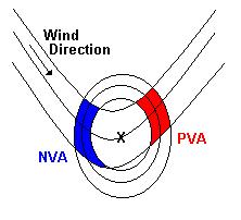 The closed circles in the figure show the 500 hPa absolute vorticity
lines, the others the 500 hPa height lines. When an air parcel is moving from
an area higher vorticity to an area lower vorticity this is called: PVA
(red color). The other way around is called: NVA (blue color). PVA is
associated with upper-air divergence, i.e. upward vertical motion. NVA
is associated with down ward vertical motion. Therefore, PVA at 500
hPa is strongest above a surface low, while NVA at 500 hPa is strongest
above a surface high.
The closed circles in the figure show the 500 hPa absolute vorticity
lines, the others the 500 hPa height lines. When an air parcel is moving from
an area higher vorticity to an area lower vorticity this is called: PVA
(red color). The other way around is called: NVA (blue color). PVA is
associated with upper-air divergence, i.e. upward vertical motion. NVA
is associated with down ward vertical motion. Therefore, PVA at 500
hPa is strongest above a surface low, while NVA at 500 hPa is strongest
above a surface high.
In operational meteorology Vorticity advection maps are used to identify areas with vertical air motion to see where clouds, precipitation or clear conditions are likely to occur. Keep in mind, however, that PVA is not the same as upward vertical motion. Here temperature advection is important too.
 The closed circles in the figure show the 500 hPa absolute vorticity
lines, the others the 500 hPa height lines. When an air parcel is moving from
an area higher vorticity to an area lower vorticity this is called: PVA
(red color). The other way around is called: NVA (blue color). PVA is
associated with upper-air divergence, i.e. upward vertical motion. NVA
is associated with down ward vertical motion. Therefore, PVA at 500
hPa is strongest above a surface low, while NVA at 500 hPa is strongest
above a surface high.
The closed circles in the figure show the 500 hPa absolute vorticity
lines, the others the 500 hPa height lines. When an air parcel is moving from
an area higher vorticity to an area lower vorticity this is called: PVA
(red color). The other way around is called: NVA (blue color). PVA is
associated with upper-air divergence, i.e. upward vertical motion. NVA
is associated with down ward vertical motion. Therefore, PVA at 500
hPa is strongest above a surface low, while NVA at 500 hPa is strongest
above a surface high. In operational meteorology Vorticity advection maps are used to identify areas with vertical air motion to see where clouds, precipitation or clear conditions are likely to occur. Keep in mind, however, that PVA is not the same as upward vertical motion. Here temperature advection is important too.
COAMPS:®
The Coupled Ocean/Atmosphere Mesoscale Prediction System (COAMPS®) has been developed by the Marine Meteorology Division (MMD) of the Naval Research Laboratory (NRL). The atmospheric components of COAMPS®, described below, are used operationally by the U.S. Navy for short-term numerical weather prediction for various regions around the world.
The atmospheric portion of COAMPS® represents a complete three-dimensional data assimilation system comprised of data quality control, analysis, initialization, and forecast model components. Features include a globally relocatable grid, user-defined grid resolutions and dimensions, nested grids, an option for idealized or real-time simulations, and code that allows for portability between mainframes and workstations. The nonhydrostatic atmospheric model includes predictive equations for the momentum, the non-dimensional pressure perturbation, the potential temperature, the turbulent kinetic energy, and the mixing ratios of water vapor, clouds, rain, ice, grauple, and snow, and contains advanced parameterizations for boundary layer processes, precipitation, and radiation.
The atmospheric portion of COAMPS® represents a complete three-dimensional data assimilation system comprised of data quality control, analysis, initialization, and forecast model components. Features include a globally relocatable grid, user-defined grid resolutions and dimensions, nested grids, an option for idealized or real-time simulations, and code that allows for portability between mainframes and workstations. The nonhydrostatic atmospheric model includes predictive equations for the momentum, the non-dimensional pressure perturbation, the potential temperature, the turbulent kinetic energy, and the mixing ratios of water vapor, clouds, rain, ice, grauple, and snow, and contains advanced parameterizations for boundary layer processes, precipitation, and radiation.
NWP:
Numeryczna prognoza pogody - ocena stanu atmosfery w przyszłości na podstawie znajomości warunków początkowych oraz sił działających na powietrze. Numeryczna prognoza oparta jest na rozwiązaniu równań ruchu powietrza za pomocą ich dyskretyzacji i wykorzystaniu do obliczeń maszyn matematycznych.
Początkowy stan atmosfery wyznacza się na podstawie jednoczesnych pomiarów na całym globie ziemskim. Równania ruchu cząstek powietrza wprowadza się zakładając, że powietrze jest cieczą. Równań tych nie można rozwiązać w prosty sposób. Kluczowym uproszczeniem, wymagającym jednak zastosowania komputerów, jest założenie, że atmosferę można w przybliżeniu opisać jako wiele dyskretnych elementów na które oddziaływają rozmaite procesy fizyczne. Komputery wykorzystywane są do obliczeń zmian w czasie temperatury, ciśnienia, wilgotności, prędkości przepływu, i innych wielkości opisujących element powietrza. Zmiany tych własności fizycznych powodowane są przez rozmaitego rodzaju procesy, takie jak wymiana ciepła i masy, opad deszczu, ruch nad górami, tarcie powietrza, konwekcję, wpływ promieniowania słonecznego, oraz wpływ oddziaływania z innymi cząstkami powietrza. Komputerowe obliczenia dla wszystkich elementów atmosfery dają stan atmosfery w przyszłości czyli prognozę pogody.
W dyskretyzacji równań ruchu powietrza wykorzystuje się metody numeryczne równań różniczkowych cząstkowych - stąd nazwa numeryczna prognoza pogody.
Zobacz Wikipedia, Numeryczna prognoza pogody, http://pl.wikipedia.org/wiki/Numeryczna_prognoza_pogody (dostęp lut. 9, 2010, 20:49 UTC).

Times:
available
selected
available (previous base)
not available
Reklamy